MASAI: Pioneering Damage Assessment Through AI and Satellite Technology
The MASAI project (Map for Damage Assessment with Satellite Artificial Intelligence) marks a significant innovation in the field of damage assessment, combining advanced technologies such as Synthetic Aperture Radar (SAR), Very High-Resolution (VHR) imaging, and Artificial Intelligence (AI). This cutting-edge approach aims to enhance the speed and accuracy of assessing damage to buildings and infrastructure following natural disasters or humanitarian crises.
Project Overview
MASAI stands out for its unique features:
- SAR Screening Module: Utilizes interferometric processing of Sentinel-1 SAR images to identify the most severely damaged areas.
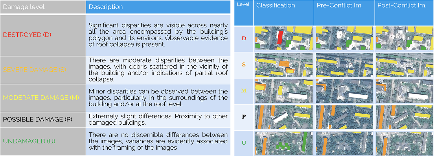
- High-Resolution Optical Module: An AI-based change detection algorithm analyzes VHR satellite imagery in urban areas, assessing the degree of damage.
- Web-Based Integrated Platform: A geographic web platform integrates outputs from the SAR and optical modules, facilitating data visualization and analysis.
- Damage Verification and Validation: Uses ground truth data, crowdsourced information, and expert analysis to validate the results.
- Pilot Demonstration: The MASAI prototype will be integrated into the operational context of the end-user, the Italian Red Cross Association, for pre-operational validation.
Key Benefits
– Supports humanitarian crisis response and post-disaster reconstruction programs.
– Adaptable to different contexts, including natural disasters and conflicts.
– Reduces time, labor, risks and costs associated with damage assessments.
– Provides objective and reproducible results, enabling consistent comparisons over time.
– Informs decisions on the relocation of affected populations and resource allocation.
– Combines SAR and optical techniques for enhanced temporal and spatial resolution.
– Facilitates collaborative knowledge generation and problem-solving.
– Offers potential for integration with open standards and other systems.
Project Consortium
The MASAI project is a collaborative effort involving a diverse group of partners, including TerrAria srl (Prime Contractor, AI algorithms, web platform development), EUCENTRE Foundation (Ground truth data, damage identification procedures, Dissemination), Gisky srl (SAR interferometric analysis and coherence analysis), Politecnico di Torino (Support for change detection algorithm development), and Croce Rossa Italiana (End-user).
Conclusion
The MASAI project represents a significant leap forward in leveraging satellite technology and AI for quick and accurate damage assessments in scenarios of humanitarian crises and natural disasters. By integrating SAR, VHR imaging, and AI, the platform offers a comprehensive and efficient solution to support aid organizations, enhance emergency response, and facilitate post-disaster recovery efforts.
This innovative approach not only exemplifies how technology can aid in crucial moments of need but also sets a new standard for damage assessment methodologies worldwide. As we move forward, the MASAI project’s impact on disaster response and recovery is expected to grow, providing vital support to affected communities and aiding in the efficient allocation of resources for rebuilding and rehabilitation.